Connecticut Lakes Gps Charts 4.4.3.5
Paid Version
Publisher Description
Connecticut Lakes Gps Charts - Marine and Fishing Charts - The power of a GPS plotter in the palm of your hand
Flytomap is a valid and interesting alternative,
Featured on the Deck
Featured on Geomedia
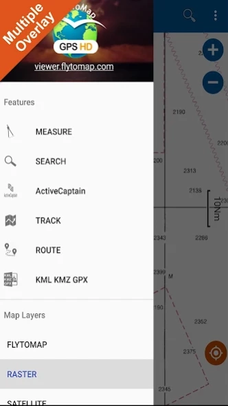
Worldwide Marine and Outdoor Maps available when connected, thanks to viewer.flytomap.com
Worldwide Satellite images overlay on charts
Worldwide Terrain features overlay on charts, thanks to Open Street Map, Open Cycle Map, Earth,topo maps by ESRI
Use to Explore:
√ Latitudes and Longitudes to go to your favorite places
√ Search your Favorite points directly
√ Zoom, Rotate and Pan fast just by a finger touch
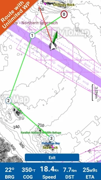
√ Route with unlimited waypoints
√ With Head Up and Course Up feature
√ Geocompass
√ Navigate and see your GPS position on the map
√ Heading Vector Towards the direction movement
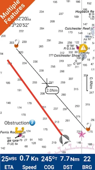
√ Distance Measurement Tool to easily calculate the distance from one location to another
√ Insert the target/destination and see in real time your speed, distance and bearing
√ background mode - Flytomap works in background as well, you can swap with another app and receive/make calls send sms while panning and zooming.
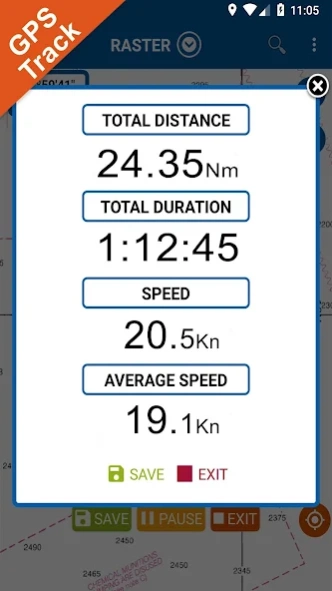
√ Unlimited Tracks share via email, visible on Google, Flytomap Viewer, KMZ format - Store your track without the need of cellular data or mobile signal
√ KMZ KML from / to GPX Converter
√ And so much more to come - It’s the only app you will ever need! Our charts are installed on: NAVICO LOWRANCE B&G NORTHSTAR EAGLE SIMRAD
Follow us:
▶Twitter @flytomap
▶Web Site flytomap.com
▶Web App viewer.flytomap.com
▶Facebook facebook.com/flytomap
The entire cartography of Connecticut Lakes is included in this application
Alexander Lake
Algonquin Pond
Amos Lake
Anderson Pond
Ashland Pond
Aspinook Pond
Avery Pond
Babcock Pond
Ball Pond
Bantam lake
Barber Pond
Bashan Lake
Batterson Park Pond
Beach Pond
Beachdale Pond
Beseck Lake
Bigelow Pond
Billings Lake
Black Pond1
Black Pond2
Bolton Notch Pond
Breakneck Pond
Burr Pond
Butterworth Brook Reservoir
Candlewood Lake
Cedar lake
Chapman Pond
Colebrook River Lake
Crescent lake
Crystal Lake
Crystal Lake(Middle Town)
Day Pond
Dodge Pond
Dog Pond
Dooley Pond
Eagleville Pond
Frash Pond
Gardner Lake
Glasgo Pond
Gorton Pond
Great Hill Pond
Green Fall Pond
Halls Pond
Hamburg Cove
Hampton Reservoir
Hatch Pond
Higganum Reservoir
Highland Lake
Holbrook Pond
Hopeville Pond
Horse Pond
Howells Pond
Jackson Cove
Jurovaty Pond
Keeney Cove Upper
Keeney Cove Lower
Killingly Pond
Lake Chamberlain
Lake Hayward
Lake Kenosia
Lake Lillinonah
Lake Mcdonough
Lake of lsles
Lake Saltonstall
Lake Waramaug
Lake Winchester
Lake Wintergreen
Lantern Hill Pond
Leonard Pond
Lilly Pads on Pond
Little Pond
Long Pond
Lower Bolton Lake
Maltby Lake
Maltby Lakes Lower
Maltby Lakes West
Mamanasco Lake
Mansfield Hollow Lake Upper
Mansfield Hollow Lake Lower
Mashapaug Pond
Messerschmidt Pond
Middle Bolton Lake
Congamond Lake Middle Pond
Millers Pond
Mohawk Pond
Mono Pond
Moodus Reservoir
Moosup Pond
Morey Pond Lower
Morey Pond Upper
Mount Tom Pond
Mudge Pond
Nod Brook state wildlife area pond lower
Nod Brook state wildlife area pond upper
North Farms Reservoir
Congamond Lake North pond
Norwich Pond
Pachaug Pond
Park Pond
Pattaconk Reservoir
Pattagansett Lake
Pecausett Pond
Peck Pond
Pickerel Lake
Pine Acres Lake
Pink House Cove
Powers Lake
Quaddick Reservoir lower
Quaddick Reservoir upper
Quinebaug Pond
Quonnipaug Lake
Rainbow Reservoir
Red Cedar Lake
Rogers Lake
Roseland Lake
Salmon Cove
Saugatuck Reservoir
Schreeder Pond
Shenipsit Lake
Silver Lake
Congamond Lake South Pond
South Spectacle Pond
Square Cove
Stillwater Pond
Stump Pond
Tyler Lake
Uncas Pond
Upper Bolton Lake
Wangumbaug Lake
Washinee Lake
Washining Lake
West Branch Reservoir
West Hill Lake
West Side Pond
West Thompson Lake
Wethersfield Cove
Wharton Brook State Park
Williams Pond
Wononskopomuc Lake
Wood Creek Pond
Wyassup Lake
About Connecticut Lakes Gps Charts
Connecticut Lakes Gps Charts is a paid app for Android published in the Geography list of apps, part of Education.
The company that develops Connecticut Lakes Gps Charts is FLYTOMAP INC. The latest version released by its developer is 4.4.3.5.
To install Connecticut Lakes Gps Charts on your Android device, just click the green Continue To App button above to start the installation process. The app is listed on our website since 2020-12-22 and was downloaded 40 times. We have already checked if the download link is safe, however for your own protection we recommend that you scan the downloaded app with your antivirus. Your antivirus may detect the Connecticut Lakes Gps Charts as malware as malware if the download link to com.flytomap.marineapp.worldviewer.connecticutlakes is broken.
How to install Connecticut Lakes Gps Charts on your Android device:
- Click on the Continue To App button on our website. This will redirect you to Google Play.
- Once the Connecticut Lakes Gps Charts is shown in the Google Play listing of your Android device, you can start its download and installation. Tap on the Install button located below the search bar and to the right of the app icon.
- A pop-up window with the permissions required by Connecticut Lakes Gps Charts will be shown. Click on Accept to continue the process.
- Connecticut Lakes Gps Charts will be downloaded onto your device, displaying a progress. Once the download completes, the installation will start and you'll get a notification after the installation is finished.
